 Seeing a Subway and since it is almost lunch time, we stop for two sandwiches to go. Between Montrose and Ouray, we find a turn out along a fast moving stream
 and have our picnic.
The next point of interest is Ouray, an old mining town popular with wealthy tourist in the late 1800's. It is now a quaint little tourist town.
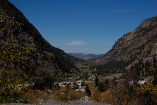 There are the ruins of many old mining operations along the road heading up Red Mountain Pass.
After 13 miles of switch backs, dizzying drop offs on Carolyn’s side, pretty fall colors
 and about 25mph we reach the top...11,018 feet!
  We drop a little and drive through a narrow valley
 for a short way and then climb again for Molas Pass at 10,899 feet. We repeat this dropping and climbing one more time for Coal Bank Pass at 10,640 feet.
Then we drop down to Silverton. This was also a big mining area back in the late 1800's and is now a popular tourist town.
 There is skiing here in the winter, but it is probably most famous for the Durango and Silverton Narrow Gauge Railroad. This is a spectacular train ride with a coal burning engine though the mountains. They offer two round trips a day during the season. Dick and his brother rode the train as kids in 1960 and thought it was great.
From here we head down the pass to Durango, our stop for the night with a paltry 160 miles under our belt. For the first time ever, we have trouble renting a site and wind up leaving because the manager won’t rent us a good site. It is 4PM, the camp ground is virtually empty and she will only give us a back in site way in the back with, probably, no internet. We can see no less than a dozen empty pull through sites near the office and even the chart in front of her, showing the sites that are reserved, has empty pull throughs close in. Her excuse is she has a big group coming tomorrow afternoon. Oh well, there is another campground about two miles down the road and we find a nice big pull through site there with a good free internet connection. Dick gets things set up and we sit outside and enjoy cocktails. The campground is right beside the narrow gauge track so we watch the two trains, full of happy, tired looking passengers, head to the Durango station with ehe engines billowing black coal smoke.
 Fortunately, the breeze carries the smoke away from the campground. Dick checks the GPS and finds that we are just under a 1000 miles from home any way we go so we work on a route and cook the last of our Alaskan salmon for dinner.
 Actual sunrise was at 7:28AM. There aren’t too many people out. We walk along the rim
 and get some nice pictures.
 We then stop at the Visitors Center and watch the movie, get a stamp for the book and get a pin for Jack. We see some mule deer on the way back to the rig.
 Dick gets the rig and car hooked up and we are on the road by 9:30AM. We head east on Hwy 12, one of Utah’s scenic byways. We again field of ice where the farmers have watered to help protect the crops from the freezing temperatures.
 It passes by several State Parks and goes through Grand Staircase - Escalante National Monument. It is a very dramatic drive as we wind through canyons and up and over ridge lines in all shades of cream, brown and red with a touch of bright green and yellow in the trees along the few streams.
 We really like this drive. At one point, high above the Escalante River, we are driving on the top of the ridge on a two lane road (Devil’s backbone),
 there is no shoulder and it is straight down a 1000 feet to the river on one side
 and to Calf Creek on the other.
 This section of the road was not paved until the 1985.
 We cross over the 9,000 plus foot summit and have a grand view toward Capitol Reef National Park.
 We get to Capitol Reef, a rugged red line of high cliffs,
 massive domes, soaring spires,
 stark monoliths,
 twisting canyons and graceful arches that were a huge barrier to the early westward movement. We turn northeast. It is a great drive through the park. The formations are grand. We were here in 2003, so we don’t spend too much time, just took a few pictures.
 and head straight to Grand Junction, Colorado. We get to the camp ground about 7PM. It has been a long day, but the drive was pretty.
 The good thing is we now have a short day for tomorrow, about 100 miles as we drive over Red Mountain Pass to Silverton and Durango, CO.
  There are limitations on the size of rig that can enter the park. There is a spiral tunnel that is only 13 feet at the center and slopes down to 11feet. So if a rig is over 11 feet they have to pay an extra fee and then traffic is stopped so the rig can go through, exactly in the middle...fun! When we get to the tunnel traffic is backed up both ways because of the rigs needing to have the road one way. Coming out later in the afternoon there are no rigs needing to use the tunnel so we breeze right through.
 We are basically high on the plateau looking both up and down at formations caused by erosion.
 Once through the tunnel we drop quickly on a snake of a road to the canyon floor. It is a pretty spectacular descent! It is very crowded today, we have to go out the south gate and park on Hwy 9 walk back to get to the Visitors Center.
 with the river winding though it.
 We get off the bus and walk the trail a short distance. This trail leads to the narrows after about a mile and a half, where you have to actually walk in the river to go farther.
 until we get back to the bus stop and board the waiting bus. On the way in, we decided to get off at stops for the Big Bend, the Lodge and the Court of the Patriarchs on the way out. The Big Bend has a nice view of tall walls of the canyon and is the starting point for a climb to the top. They say that it is some view from there!
  We can see people walking on the trails at the top of the canyon.
 This is a great park and there is really a lot to do. We think we will come back next October, stay in the lodge and do a few of the easier hikes.
 I guess we spend about three pleasant hours in the park
 plus the drive down and back to Bryce. We get back to Bryce about 5PM and head to Sunset Point.
 This is a great view.
 There are hundreds of Hoodoos in somewhat of a semi circular canyon.
 With the sun so low in the sky, they glow like they are on fire!
 If you look at the Hoodoos closely you can imagine castles,
 temples
 and all sorts of things. The big picture looks like an amphitheater full of people.
 We still want to see the Visitors Center’s movie and Sunrise Point, but will do that in the morning before we leave. We go back to the rig and fix Mexican food for tonight plus fix some main dishes to heat up for meals as we travel the last stretch to Texas.