The highway down to Tok where we pick up the ALCAN again is even worse in places than the road into Chicken. There was a huge fire through this area, the Fortymile River area, in the summer of 2004. It burned 6 million acres from May to September that year. As far as the eye can see in places there is nothing except the new growth and the fireweed plant that is the first thing to come after a burn. The mountains all have a purple-pink hue right now.
 Actually, having seen it before the fire and now is interesting as we can see all the twists and turns of Fortymile River and its streams now that the land is a meadow.
 We stop in Tok at the Visitors Center and get a wealth of information on things to do and see in Alaska. Dick saw a lube place as we came into town with big bays. We go back to see about an oil change. The guy can change the oil as soon as he finishes what he is working on. So we have lunch in the rig while we wait. He gets to us very fast and checks everything out. He says we have a wheel problem, probably an alignment issue so that is one more thing we will get checked out in Fairbanks this week.
Back on the ALCAN again, we head to Delta Junction and the official end of the ALCAN. This is another pretty section of the Highway with high mountains on one side and a river on the other.
 At one point we cross a long bridge over a trickle of water that must be a ragging tourent during the Spring melt from the looks of the river bed.
 There is a pull off at the end of the bridge, so Dick turns off and drives out to the edge of the river bank.
  We get out for walk along the rocky shore doing some rock hounding and enjoying the views of the snow capped mountains.
 Across the street is the old Sullivan Roadhouse that was originally 18 miles down the road. It has been set up like it would have been at the turn of the last century.
Now, heading north on the Richardson Highway, we follow rivers again.
 It is getting late in the afternoon and we are ready to stop for the day. We find a RV park, Lazy Moose, right on the river with full hook ups and it is empty! Checking it out, we find it is on an honor system so we make ourselves at home
  and have a pleasant evening, sitting out side in the warm sun watching the river go by!
 The park actually has internet too, so Dick contacts Dell about Carolyn’s computer problem and makes arrangements for the screen to be replaced while we are in Fairbanks. Carolyn's computer being out of commission makes get the blog up harder. Dick doesn't share well!
 Carolyn fixes a light meal of fettuccini and after a beautiful day we call it quits in the land of the midnight sun!.


 and head over to the ferry that connects Dawson City to West Dawson across the Yukon River. The ferry runs until ice starts to form in the river and then, usually about three weeks later, sometime in November, the ice bridge opens to traffic untill about April when there are another three or so weeks while the ice breaks up and the ferry can starts running again. People living in West Dawson have about six weeks to two months a year where they are rather isolated!
 It doesn’t take long to cross and we are on our way. The Top of the World Highway climbs up into the mountains and runs along the ridge line for 65 miles.
 It is a beautiful drive and we can see for miles both north and south.
 The road was freshly seal coated when we came across in 2002, but today it is not in as good condition with many breaks and long stretches of gravel. There is absolutely nothing except road, scenery and a few gold mining ghost towns. The border crossing is in the middle of nowhere
 with two Americans and two Canadians manning their respective post, very lonely duty!
 We stop at the official welcome sign for Alaska for pictures, we made it!
 Heading on up the road a way, we stop at another pretty overlook and visit with two Germans on their way to Dawson City in a rented RV.
 The road on the US side is awful, with lots of wash boarding and wash outs on the outside lane, but the views are beautiful
  and we make the 35 miles down the mountain, with only a little tooth jarring, into the booming metropolis of Chicken, Alaska! Chicken is a gold mining town
 from the 1900's and is today home to a US Post Office
 and three businesses: two RV parks and "Down Town Chicken", a café, saloon/liquor store and gift shop.
 As we pull into "Down Town Chicken", two Holland American tour buses pull out on their way to Canada. We are glad we did not meet them coming down the gravel road!
 We are at the back end of the campground near the Pedro Dredge that use to work the mines around here. We and another rig are their only takers for tonight. There is internet supposedly, but we can’t connect. Also, when Carolyn turns on her computer, the screen is garbage. Great, hopefully we can get that dealt with in Fairbanks!
  the location of the first gold strike in1896. The picture above is the actual location of the first gold strike in August 1896. There are channels of gravel all along the creek bed and up onto the hill sides from all the dredging work.
 Gold is still being mined and there are KEEP OUT signs all along the road. Several miles up the road are two National Park areas, one around Dredge #4 and the other at Discovery Claim, the site of the first strike, and Claim #6, a place where you can pan free using only hand tools. The Dredge is huge.
 It is the largest wooden-hulled, bucket-line, gold dredge in North America and has definitely left its mark in Bonanza Creek.
 We get out and wander around doing a bit of rock hounding, but the water is too cold and the ground too muddy to really get into the panning scene.
 for a little skit put on by the parks department summer workers. It is OK, but the movie on the Gold Rush is better. The theater has been restored to its original grandure.
 At 5:30PM we head down to the Yukon River landing for a two-hour river ride on the side wheeler, Klondike Spirit.
 We go down river far enough to see the First Nation village of Moosehide
 and then turn around and go by the steamboat boat graveyard.
 We then pass a First Nation fishing Camp and finally turn around in the area of a back woodsman, dog trainer, trapper.
 It takes a hour and a half to go upriver and ten minutes to go back down, or put another way...it took four to five days to go from Dawson City to Whitehorse up river and about 21 hours to come back down river from Whitehorse to Dawson City!
 Back at the rig, a little after 8PM, we fix quiche for supper and think about going to Diamond Tooth Gertie’s CanCan show at 10:30PM; but not very hard!
 This section of the highw
 ay follows lake shores or rivers and is nice and scenic. The road is deteriorating as we go north though.
 and pass through Carmacks, established as a trading post in 1890's. We stop for a picture of the river valley
 just before Five Finger Rapids, where the river divides into five channels. The road is really rough now with many gravel sections but fortunately there is very little traffic.
 fix lunch and enjoy the view out over Pelly River. From now on the road is mostly built up with bogs on either side that your car could disappear in or small streams
 and beaver lakes.
 We feel like we are riding a roller coaster due to all the frost-heaves. They are marked with orange flags just before you hit them so you know the heaves are coming and can "hold on"! We also get into rain so that just adds to the thrill.
  About 4PM we get to Dawson City in a misty, sunny rain and find a gravel parking place for the rig at a campground in town. The campground is well maintained and not full, so it really is not as bad as it sounds. We relax for a while and then fix some Mexian food. It has been a long day so, Dick goes to bed early and Carolyn works on the around the world picture books for a while.
 This is a pretty little day use park on the shores of a crystal clear lake with a nice swimming beach. Brrr....!. After the lunch break, we head down the road to the historic Robinson Road House.
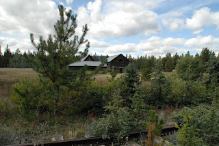 It is a short hike back in the woods across the tracks to the old timber "village", a roadhouse and saloon,
 several log and sod roofed cabins
 and out buildings,
 along side the railroad tracks. This roadhouse was in its hey day in the 1890s. It was a transfer station, train to wagon, for goods being transported on the railroad before it was completed into Whitehorse.